
Participatory Sensing and Waste-Truck Pollution Monitoring in Fujisawa

✅ Finalized

📍 Fujisawa, Kanagawa, Japan

About

🗓️ Start: 2016-07-01

⇨

🗓️ End: 2019-06-30
UTA members Keio University and NTT East, working with UTA member city Fujisawa, turned moving sources into a city-wide data network under the EU–Japan BigClouT project: city officers filing geolocated photo reports of illegal dumping, missed collections and damaged facilities through the MinaRepo app, refuse collection vehicles measuring air quality street by street with thirteen types of sensor, and festival-goers sharing live crowd updates through an app and signage.

Short Description

Fujisawa is a coastal city in south-central Kanagawa Prefecture, home to about 440,000 people. It sits on Sagami Bay between Tokyo and Yokohama, has a large commuting population, and draws visitors to Enoshima and its beaches. Keio University’s Shonan Fujisawa Campus (SFC), the research base for this pilot, is located in the city.

The participatory sensing and waste-truck pollution monitoring pilot tackled a common gap in city data: most environmental and infrastructure information comes from a handful of fixed stations and from whatever problems people happen to report. UTA members Keio University SFC and NTT East worked with Fujisawa City to combine fine-grained sources — structured reports filed through a participatory sensing app, continuous air quality readings from sensors mounted on the city’s refuse collection vehicles, and live information shared by participants at city festivals.

Pilot Overview

Cities often know less about their own environment than it appears. Air quality is usually measured at a few fixed stations, and conditions everywhere else are estimated from them. For pollutants that change over short distances — dust, traffic gases, pollen — most of the city is never directly measured. Infrastructure has the same blind spot: the city learns about damage or illegal dumping only when someone reports it, and those reports often lack a clear location or category.

BigClouT — big data meeting Cloud and IoT to empower citizen involvement in smart cities — was the EU–Japan project under which Fujisawa addressed both problems. It was jointly supported by the European Commission under Horizon 2020 (grant agreement 723139) and by Japan’s National Institute of Information and Communications Technology, ran from 1 July 2016 to 30 June 2019, and operated in four pilot cities: Grenoble, Bristol, Fujisawa and Tsukuba. It followed the earlier EU–Japan ClouT project, in which Fujisawa had worked alongside Santander, Genova and Mitaka. Rather than starting from zero, BigClouT expanded the Fujisawa set-up and connected it to a new platform and analytics layer.

The pilot’s central idea was to collect data through operations the city already runs. Refuse collection vehicles are ideal carriers: they travel every street on a regular schedule. Fitted with environmental sensors, their normal rounds become a steady, detailed survey of the city that can be tracked over time and across neighbourhoods. The same logic applies to reporting. Fujisawa’s garbage section officers already cover the city as part of their jobs; with MinaRepo, a structured app, they turn what they see into records with a photo, a location and a category rather than phone calls, faxes or paper notes.

One dataset, two kinds of value. For residents, street-level pollen and PM2.5 readings help decide when and where to go outside. For the city, the same location and route data helps optimise collection rounds, cutting mileage and CO₂ emissions — which makes the sensing part of daily operations rather than a research add-on.

The same participatory approach was also tried on crowds. At two city festivals in 2017, BigClouT tested whether sharing live information between organisers and visitors — through a smartphone app and signage at the venues — could change how people move between event areas and ease congestion.

Challenges Addressed

The pilot addressed four connected challenges in environmental and waste management data.

Pollution data was sparse. Fixed monitoring stations measure air quality at only a few points. Conditions in between — most of the city — are estimated rather than measured, so rapid local changes in dust, traffic gases and pollen go unnoticed.

Incident reports were inconsistent. Illegal dumping, disposal errors, missed collections and facility damage were reported without reliable location or category information, leaving the city with no aggregate view of where problems recur.

Dense sensing is expensive. Achieving fine-grained coverage with fixed devices would require many more sites, plus equipment, power, permits and maintenance for each — a cost most cities cannot justify for monitoring that no regulation requires.

Aggregate figures do not help individuals. City-wide or regional air quality numbers cannot tell a resident whether pollen or dust is high where they live, work or plan to walk.

Solutions Tested

Achieved Results

A mobile environmental monitoring network was established across Fujisawa using refuse collection vehicles as the sensing platform. The vehicles measured thirteen atmospheric parameters at street level, with GPS positions updated every second and readings transmitted every 30 seconds — a level of detail that fixed monitoring stations cannot match at a comparable cost.

A structured incident reporting system was put into daily use. From 6 October 2016, 65 officers in Fujisawa’s garbage section used MinaRepo in their routine work, reporting illegal dumping, uncollectible waste, graffiti, road damage and similar problems. Each report is published through the city sensing platform (SOXFire), stored with its location and category, and can be confirmed, discussed and acted on by other officers through a web map and list view — replacing telephone, fax and paper handovers.

By March 2018 the officers had filed 3,667 reports — about 56 per user. Chiba City’s citizen-reporting service ChibaRepo, used for comparison, collected 1,873 reports from 3,615 citizens over a longer period, about 0.5 per user. Mapping both datasets showed that reporting by civil officers gave far wider and more even spatial coverage than reporting by residents, and a questionnaire confirmed that the system made officers’ daily work more efficient.

The data proved useful for analysis as well as operations. Combining MinaRepo reports with housing and population statistics for 192 sites, the team trained regression models to predict the amount of uncollectible garbage at each site. Ridge regression using both types of statistics performed best, and the models linked housing typical of young people living alone to higher levels of uncollectible garbage — insight the city can use to target waste guidance.

The festival trials put participatory sensing in front of the public. At the Fujisawa Citizens’ Festival (藤沢市民まつり, 23–24 September 2017) and the Fujisawa Choi-Nomi Festival (ふじさわ ちょい呑みフェスティバル, 7–8 November 2017), visitors used Rokemon, a Keio University smartphone app in which users anonymously share updates through virtual “location monsters” stationed at each venue — for example, that a parade is about to start or that a food stall has no queue. Signage at the venues displayed the event programme, traffic restrictions and the updates exchanged in the app. NTT East coordinated the trials, Keio SFC provided the app and behavioural research, and Fujisawa City provided the festival venues; user data was anonymised.
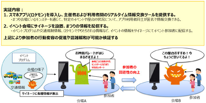
Diagram of the BigClouT festival trial in Fujisawa: the Rokemon app lets participants share live updates through location monsters, and signage at each venue shows event, traffic and crowd information

The festival trial design: the Rokemon app gives organisers and visitors a real-time channel for sharing the status of events and food stalls, while signage at each venue shows the programme, traffic information and updates from the app. The trial tested whether this could change visitor behaviour, improve circulation between venues and ease congestion. Diagram: NTT East (translated from Japanese).

Both data sources were combined on a single platform that also supported use cases in Grenoble (event impact monitoring, industrial estate optimisation), Bristol (mobility patterns and power consumption prediction) and Tsukuba (visitor information and problem reporting). The Fujisawa applications are therefore instances of a reusable system rather than one-off solutions.

The pilot demonstrated a model in which environmental sensing is built into existing city operations: the same data informs the public and helps optimise collection routes, so monitoring delivers efficiency gains instead of only adding cost.

The approach travelled. The participatory reporting method recurs across the BigClouT programme — in Tsukuba, the HukuRepo application uses the same photo-and-description reporting model for a different group of users.

The MinaRepo work was presented as “Accelerating Urban Science by Crowdsensing with Civil Officers” at UbiComp/ISWC 2018. BigClouT as a whole produced 11 conference papers and 3 peer-reviewed journal articles on participatory sensing, environmental data analysis, edge computing and spatio-temporal urban computing, together with around 10 smart city use-case scenarios and their associated business models.

What came next. The platform and use-case patterns were carried over to other BigClouT cities and into follow-on smart city work in Japan and Europe. Structured citizen reporting has since become part of how Fujisawa runs its public spaces: from March 2022, residents can report park facility problems directly through the city’s official LINE account.

Innovators

Share the Post: