
Smart Mobility, Walkability and Air Quality in Bristol

✅ Finalized

📍 Bristol, United Kingdom

About

🗓️ Start: 2016-07-01

⇨

🗓️ End: 2019-06-30
Bristol City Council and Bristol is Open, working with Lancaster University as part of the BigClouT group, developed a pollution-aware walking route service on the BigClouT platform, which guides pedestrians along routes that avoid the most congested and polluted streets, not just the shortest ones.

Short Description

Bristol, the largest city in south-west England with around 470,000 people, has led smart city initiatives. In April 2015, Bristol City Council and the University of Bristol launched Bristol is Open, a joint project to test new technologies across the city. They focused on areas like software-defined networking, IoT, 5G, machine learning, and CCTV analytics. Bristol is Open ran three main projects: BigClouT, REPLICATE, and 5G Smart Tourism. After three years, the council took full ownership.

Bristol joined BigClouT as a new pilot city, alongside Grenoble and Tsukuba, while Fujisawa continued from the earlier ClouT project. The city had a major problem: nitrogen dioxide levels in central Bristol often exceeded legal limits, so the government required a plan to address it. In January 2019, the government threatened legal action because of delays, and the council submitted its Clean Air Zone plan the following month. The pilot aimed to answer a practical question that existing policies could not solve quickly: if air quality is poor on a certain street today, can pedestrians choose a different route?

Bristol City Council and Bristol is Open, working with Lancaster University as part of the BigClouT group, developed a pollution-aware walking route service. The service combines pedestrian movement and air-quality data in the BigClouT data lake to optimise walking routes, so people can avoid heavily congested and polluted streets rather than simply taking the shortest path. This helps users avoid streets with the highest nitrogen dioxide levels. The approach makes air quality a factor in route planning, much like how mapping apps use traffic data. It lets people make informed choices based on current conditions, even if the bigger issue is not yet solved.

Key goal or objective

The aim was to help people avoid walking routes with high pollution in central Bristol by using real-time mobility and air-quality data to guide them. This gave residents and tourists a way to reduce their own exposure while the city worked on long-term solutions to lower nitrogen dioxide levels.

Pilot Overview

At this time, Bristol had a serious air quality problem. Monitoring in the city centre showed nitrogen dioxide levels above the legal limit for several years, sometimes even double the limit. Because of this, the government told the council to make a plan. When the plan was delayed, campaigners threatened legal action in January 2019. The council submitted its Clean Air Zone proposal in February 2019, but the zone did not start until November 2022.
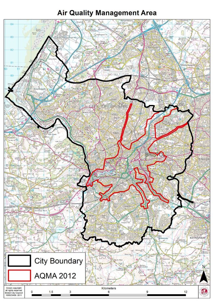
Map of Bristol showing the city boundary in black and the 2012 Air Quality Management Area in red, covering the city centre and main radial roads
Bristol’s Air Quality Management Area (red), designated in 2012, within the city boundary (black). Map: Bristol City Council, © Crown copyright.

This timeline highlights the gap the pilot wanted to address. Big changes like charging zones, updating vehicles, or changing road layouts take years to plan and complete. In the meantime, people still walk the same streets. Pollution levels vary across the city centre. For example, a main road might have much more pollution than a nearby side street. If people know which streets are cleaner, they can lower their exposure right away, without waiting for new policies.

Bristol already had the data needed for this project. The city monitored air quality in the centre and shared the data openly. Bristol is Open managed the network and analytics systems to bring these data sources together. However, the city was missing one important thing: a way to combine air-quality and mobility data so people could use it when choosing where to walk.

BigClouT filled this gap. The project used big data, cloud computing, and IoT to give citizens more say in smart cities. The European Commission funded the project through Horizon 2020, and Japan’s NICT supported the Japanese partners. The project ran from 1 July 2016 to 30 June 2019 in Grenoble, Bristol, Fujisawa, and Tsukuba, all using a shared city data platform. In Bristol, the focus was on mobility and environmental issues, using the BigClouT data lake to store and process the combined data.

Challenges Addressed

The pilot tackles four connected problems.

First, nitrogen dioxide exceedances affected residents across central Bristol. Levels breached legal limits, prompting government direction and the threat of litigation.

Second, structural remedies moved slowly. Several years passed between identifying the problem and operating a Clean Air Zone, leaving residents without a practical way to reduce their own exposure.

Third, air-quality data did not reach people at the moment of decision. Monitoring stations produced readings and the council published them, but people choosing walking routes could not use this information.

Fourth, mobility and environmental data remained in separate systems. Route guidance could optimise for distance or time, but no existing tool combined these datasets to optimise for exposure.

Solutions Tested

Current Status

Completed

Achieved Results

The pilot delivered a pollution-aware route-optimisation use case for central Bristol, combining pedestrian movement and air-quality data on the shared BigClouT platform.

The project showed that air quality can be used as a routing factor, much like how mapping tools use congestion data. It gave people a way to act immediately, even though the city’s long-term solutions were still years away. The shared BigClouT platform was also used in the Grenoble, Fujisawa, and Tsukuba pilots, showing that the same system works for both European air-quality and Japanese infrastructure-monitoring cases.

Innovators

Share the Post: