✅ Finalized
⇨
CLIMAGRE is a pilot project developed within the Climaborough initiative and implemented by Urban Technology Alliance members Kentyou, Latitudo 40, and RealSim, in partnership with Grenoble-Alpes Métropole (GAM). The pilot delivers a user-centred digital solution combining Earth observation, AI-based analytics, and a 3D Digital Twin to analyse, simulate, and mitigate Urban Heat Island (UHI) effects and support climate-resilient urban planning at both project and territorial scale.
To support evidence-based decision-making and climate adaptation strategies in Grenoble-Alpes Métropole by providing an integrated digital environment capable of evaluating the impact of urban development projects on urban overheating, thermal comfort, carbon storage, and ecosystem performance over short- and medium-term horizons.
Grenoble-Alpes Métropole is actively advancing its climate-neutrality and climate-resilience objectives through smart and sustainable urban development. As climate change intensifies heatwaves and exacerbates urban heat island effects, GAM identified the need for an integrated, scientifically robust, and operationally usable digital tool to better understand, anticipate, and mitigate urban overheating.
CLIMAGRE addresses this need by combining high-resolution environmental indicators, participatory user-centred design, and advanced simulation capabilities within a unified digital platform. The pilot focuses on the GrandAlpe area and supports the evaluation of ongoing and planned urban regeneration projects, including their cumulative effects on heat exposure, vegetation, and environmental quality.
The solution is designed to serve multiple user profiles within the metropolitan administration – from project managers and technical experts to strategic decision-makers – while also acting as a communication and awareness-raising tool for citizens and local stakeholders.
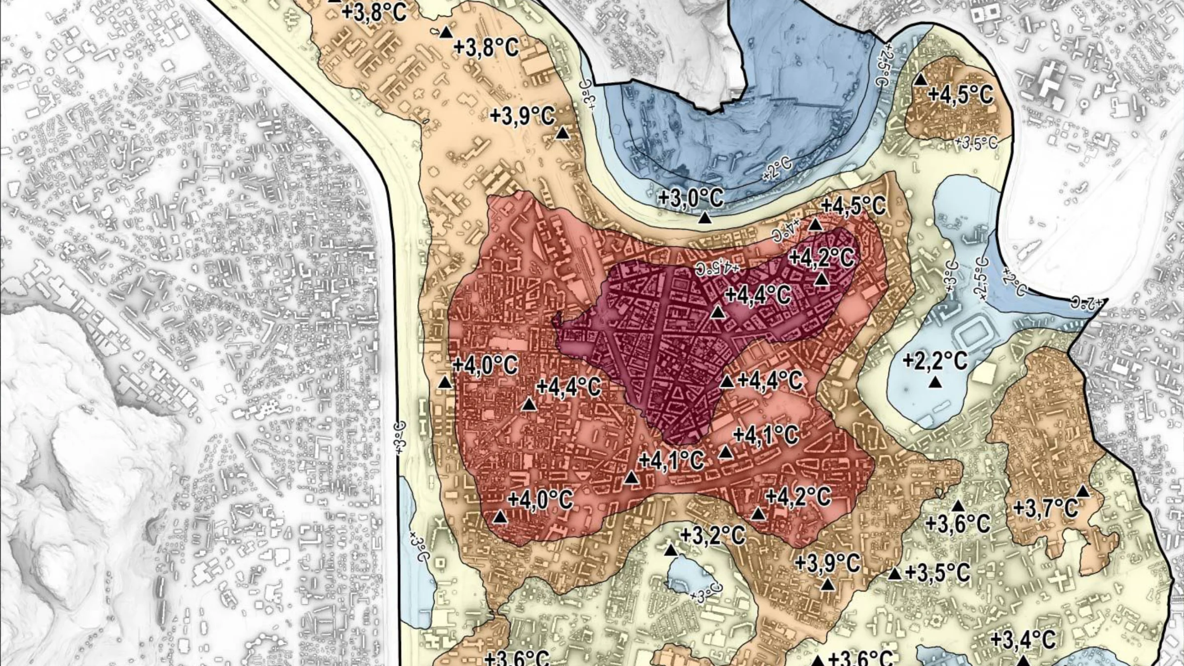
Urban Heat Islands and their environmental, social, and health impacts in a dense metropolitan context.
CLIMAGRE implements a multi-layered solution integrating complementary technologies:
A horizontal data platform built on an open and interoperable architecture collects, cleans, standardises, and synchronises data from multiple sources, including sensors, satellite imagery, open data portals, and institutional datasets. The platform ensures seamless integration with GAM’s existing IT systems and supports both real-time and historical data analysis.
High-resolution satellite data and AI-based processing pipelines are used to calculate key environmental and climate indicators, including land surface temperature, Urban Heat Island (UHI) index, Land cover maps, Tree canopy density, Pervious surface maps, Land surface temperature maps, Water bodies and carbon storage map. These indicators provide a scientifically robust basis for analysis and forecasting.
A detailed 3D Digital Twin of the Grenoble GrandAlpe area enables both micro-scale project simulations and macro-scale territorial scenarios. Users can test alternative urban design options – such as green infrastructure, cool roofs, or land-use changes – and immediately visualise their impact on UHI mitigation and environmental performance over a 5–10 year horizon.
The pilot is ongoing. The first project phase focused on user-centred design, stakeholder interviews, definition of use cases, system requirements, and solution architecture. Indicator pipelines and data integration workflows are operational, and initial Digital Twin components are in development.
Following validation in Grenoble-Alpes Métropole, the CLIMAGRE approach is expected to be replicated in other European cities through the Urban Technology Alliance, supporting wider deployment of climate-resilient, data-driven urban planning solutions.
If you are interested in joining this transformative journey or exploring partnership opportunities, we encourage you to reach out and become part of a community that is shaping the future of our cities.